The Abberley and Malvern Hills Geopark
The Abberley and Malvern Hills Geopark, is located within the West Midlands region of the United Kingdom. The boundary of the Geopark falls within the rural counties of Herefordshire, Gloucestershire, Shropshire and Worcestershire and covers an area of 1250 square kilometres.
The Abberley and Malvern Hills form the backbone of the Geopark, illustrating over 500 million years of Earth history. Stratigraphy from Precambri-an to Jurassic and Quaternary is represented with almost complete successions of the Silurian and Triassic periods present. The Malvern structural axis with its associated faulting and folding runs in a north south direction and is the major influence on the geology of the Geopark.
Lower Thrift Farm lies midway between Clifton - upon - Teme and Whitbourne. Owned by Harvey and Diane Richards, the farm is managed under the Countryside Stewardship Scheme. Harvey and Diane are able to offer schools and other interested community groups a range of walks and activities. These can be tailored to meet many aspects of the national curriculum and both schools and adult groups may investigate subjects related to farming, the historic or natural landscape, wildlife and the countryside.
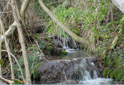
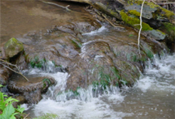
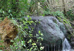
The farm takes in the River Teme, designated as a Site of Special Scientific Interest (SSSI) and several Special Wildlife Sites (SWS). One of these SWS is the Whitbourne Brook, which is of particular geological interest due to its stunning (actively forming) tufa deposits. Tufa is formed by springs emerging from beneath the Bishops Frome Limestone. The calcium carbonate dissolved in the spring water precipitates to form a soft white or grey sponge like rock. The tufa deposits often contain petrified plant and animal remains.
The delicate tufa deposits are an important "geoindicator" of current environmental status, groundwater quality and are an indicator of rapid environmental change. Tufa supports lime tolerant species and the alkaline conditions of soils make this an ideal location to demonstrate the links between geology and biodiversity. The old orchards, semi-natural ancient woodlands and old meadow pasture, lying adjacent to the brook, support a range of flora and are a haven for insects and birds.
The Geopark is pleased to support the Richards in their venture and the University of Worcester (Geopark partners), have produced worksheets, suitable for all key stages, on the geological features at Lower Thrift Farm. These complement the many activities already offered by the Richards, who are particularly keen to welcome school parties and adult groups from the surrounding towns in the counties of Worcestershire and Herefordshire. For more information or to receive an information pack on the range of educational facilities offered at Lower Thrift Farm, please contact: 01886 821116